
Red Oak receives assessment on housing from ISU students
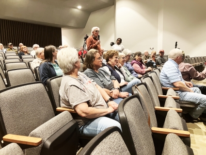
The City of Red Oak has a new floodplain and housing resilience plan.
After months of work and research, the Iowa State University Community and Regional Planning students presented the city with a plan designed to share information about what flooding means for a person’s neighborhood, strategies to reduce flood damage risk, and strategies to improve the home condition. The results of the study were shared at a special community meeting at the Red Oak Jr./Sr. High School Auditorium. City administrator Lisa Kotter said the plan started with former Red Oak Mayor Shawnna Silvius.
“When Mayor Silvius was in office, she was invited to be a member of what was called a Mayor’s Design Project through the same college. There were six mayors working together and she was one of them. They were focused on floodplain issues. And so what was born from that has culminated in this plan,” said Kotter.
The City of Red Oak received a state of Iowa economic development grant for $50,000, and the city had to put up $25,000 for a total of $75,000 for the study.
“We wanted to focus on things that were relevant in the floodplain. For those of you that are involved in city government or community things, you certainly are aware of the fact that floodplains and houses in the floodplain are definitely an issue that impacts our community. It was great to have an opportunity to work with the ISU’s 22 students. Most of them are undergrad and six of them are graduate students. All but two of them are graduating,” commented Kotter.
Carlton Basmajian, professor in the urban planning program at Iowa State said he had served as the leader of the little group for the more than three months of the study. He said it was part of an educational experience that they give to the students.
“This is part of a class that they have to take right before they graduate. So it is essentially a culmination of a lot of the work and learning they’ve done already up to this point. This is the moment when we push them into the real world and say show us what you learned by doing a real-world planning project. It varies from year to year. We work in different towns, mostly smaller cities across the state. This year we were lucky enough to work in Red Oak. It’s been a fantastic process, and the students have learned an enormous amount about the practice of planning, about floodplains, about housing, about all kinds of things, and have gotten a nice little boost from being here and interacting and doing this work as we send them out into the world,” stated Basmajian.
The ISU students then spoke about the project. Conor Ziaja said the plan included five separate sections ranging from the introduction, existing conditions, study area policy recommendations, section findings, all the way down to next steps.
“We had to ask these questions such as what does this mean for housing stock and housing affordability in towns like this? What does this mean for community growth? And these questions are things that kind of guided us along our process. So in this plan, we had to sort of have a purpose where we created an inventory of homes and their conditions in the study area. We wanted to propose strategies for improving the built environment of the neighborhoods. We studied the 100 year floodplain and the Nishnabotna and Red Oak Creek, surveying residential parcels only,” advised Ziaja.
Key findings showed that around half of the homes within the study area were within the floodplain. This could lead to added costs, making homes less affordable abd harder to maintain. Ziaja said they noted community skepticism about the accuracy and relevance of the current flood zone boundaries, and they determined a need for strategies that expand affordable housing options in lower risk areas of the community.
Information was gauged through community engagement, including meetings and a housing survey. The study areas were divided into east, north, south, and west sections in central Red Oak. Ziaja said it was divided because each section has a very different character. The west section is drastically different from the east section, and all the sections have unique challenges. They all have unique challenges, and they all have specific solutions. Again, I want to infer that this is all just central Red Oak.
ISU student Jacob Black then discussed the city’s housing stock and its housing needs.
“Red Oak has around 2,700 housing units with roughly about 900 or so of those we surveyed. The majority of the city, more than 60%, was built before 1969. notably, about 416 of the surveyed parcels are in the 1% floodplain. While there is a surplus of housing for lower-income households, options become very limited for those, earning more than $35,000 and the lack of housing a variety, which is mostly single-family homes, and kind of compound this gap, Black explained.
Black noted a lack of housing variety, primarily detached, single-family dwellings. About 23% of homeowners and 36% of renters spent more than 30% of their income on housing, and 33% of those surveyed rented their homes.
The students then shared information on the study area policy recommendations.
• Rehabilitation: repairing existing homes, making them a more suitable place to live. Rental repair program, rental permit program, rental inspection form updates, and rental feedback program to equip landlords with resources to provide housing improvements, build relationships with city landlords, and provide a space for residents to share feedback. The top five priority rehabilitation projects are windows, fascade, front steps, foundations, and front porches, and the study looked at providing a funding program for homeowners to apply for aid for the cost of restoration.
• Acquisition and development included looking at voluntary property buyouts, as well as new development and infill. Infill development is when new residential development is built on a vacant property that was rezone for residential use, Accessory Dwelling Units, small secondary housing units on existing properties such as backyard cottages or detached garage conversions. Voluntary property buyouts were also suggested,
• Environmental and natural, looking at land that may possibly be bought out, what that could look like with more natural spaces that the floodwater can go into. Land use options included community gardens and green infrastructure.
• Finally, the study looked at sidewalks and performed a condition assessment. Some were rated in very poor condition while others were in poor condition. A lot of the parcels we identified were in poor condition. ADA compliance was noted. Options for improvement included a city-coordinated sidewalk repair program, cost share, equity grants, or a 10-year special assessment deferment at low interest.
In the west section of the study, opportunities for action included rehabilitation, adaptive post buyout land use policy, or a mobile home hazard mitigation program.
The south section opportunities for action included accquisitions and development, creek access and setbacks.
North section opportunities for action were rehabilitation, acquisitions and development, home improvement, infill development, and a rental program.
Finally, in the east section, action opportunities included rehabilitation, acquisitions and development, opportunities fir multi unit living. Several large, vacant lots were ready for developing, and there were infill opportunities as well.
The ISU students said the infill opportunities were parcels that they identified with nothing on them. For parcels that the city doesn’t own, they work with the property owner to come to an agreement of what could be done on that land.
Larry Brandstetter asked about the FEMA maps, and the FEMA classifications. The students explained that those are one dimensional maps. In other words, if there was a flood, they’d consider it to be on flat ground. Brandstetter asked if the study could include the maps from the Iowa Flood center that were recently created, but the study had to use the FEMA maps, as they are the legally binding maps that the local jurisdictions go off of.
So one issue that they identified and researched is that the Iowa Flood Center maps cannot be sent in to FEMA at this time by the city because of stuff with the levy. But if that map were to be changed in the future, it would decrease the flood plain by a considerable amount on the map. Also mportant to note is that the flood plain from FEMA uses a 20 feet by 20 feet elevation data. It’s not completely one dimensional, and it does use elevation data. It’s just a lot less fine grained than the Iowa Flood Center. FEMA however is the entity that determines the flood insurance maps.
As for infill, the question was raised, especially in some locations, that if you built a $150,000 to $200,000 home, it would be surrounded by homes that had a lower valuation.
With the infill strategy that the ISU survey identified, if they were to recommend infill in some of those lower valuation areas, theywould strongly recommend that the development going into that land would be similar to what’s around it. So it wouldn’t be expensive homes but houses that were probably a little bit above the existing valuation around that land. Contextually, it would make more sense to have more basic homes. The infill strategy also prioritizes, in terms of geographic land space in the study area would be to the north and the east. In the west and the south, they recommend transitioning that land to those resilient end uses suchs as community garden spaces and areas where the flood water can actually work and soak into the ground better.
Steve Adams asked in ADU housing was an option for infill lots. The students felt that was something the city would are definitely be interested in, especially
given some of the larger lot sizes they see in the north and east sections.
Clint Rubey addressed the students, and praised them for all of the work they had done on the survey.
“I was a real estate broker here, an agent for 50 years. And the company that I owned is now in the hands of another capable individual. I don’t own it anymore. But time after time after time in the business, we came upon a problem with that floodplain. And the problem has been unsolvable in the minds of past city councils and mayors. You come up against a wall, and you go, where are we going to start? And maybe the current city council can start. And that’s the key, is to start. And you guys, I think you’ve done a fantastic job of looking at our city, here at Red Oak and analyzing what’s here, and looking at it realistically, Rubey said. “I see that you’re not saying, go down the street and order everybody out of this particular block. It has to be done diplomatically. It has to be done over a long period of time, not two years or five years, to get the progress going that we want. But you guys have done a great job. I compliment all of you for the work that you’ve done.”